Maximum Lat and Long bounds for the world - Google Maps API LatLngBounds()
Solution 1
The links provided by @Marcelo & @Doc are good for understanding the derivation of the Lat Lng:
- http://www.cienciaviva.pt/latlong/anterior/gps.asp?accao=changelang&lang=en
- https://groups.google.com/forum/?hl=en&fromgroups=#!msg/google-maps-api/oJkyualxzyY/pNv1SE7qpBoJ
- https://en.wikipedia.org/wiki/Mercator_projection#Mathematics_of_the_Mercator_projection
But if you just want an answer for the maximum bounds for Google Maps:
Latitude: -85 to +85 (actually -85.05115 for some reason)
Longitude: -180 to +180
Try it for yourself on the Google Maps:
(You may need to Zoom Out. See how the pin is at the "edge" of the world - these are the limits)
So in your code Try:
var strictBounds = new google.maps.LatLngBounds(
    new google.maps.LatLng(85, -180),           // top left corner of map
    new google.maps.LatLng(-85, 180)            // bottom right corner
);
Please edit this wiki (or update your question) once you have the answer. Thanks
Solution 2
See this post in the old Google Groups, which describes the math of the projection.
Quote:
the map doesn't start at 85 degrees, but rather the degree that makes the map square. This is can be simply calaculated as: atan(sinh(PI)) *180 / PI = 85.05112878....
Note that the tile calculation in that post is for the old API V2, but the projection should be the same.
Solution 3
You may do the following to get the Max Lat and Long bounds of the world with the help of Google Maps :
1: Set the Zoom Level 1 of Google Maps While setting up the Google Map Stuff :
mapOptions = {
                zoom: 1,
 .....
}
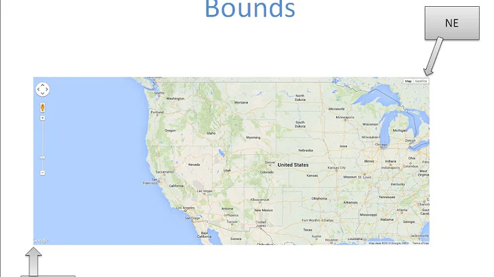
2. Do the following to get NorthEast and SouthWest Bound of this Map :
map = new google.maps.Map(document.getElementById('map-canvas'), mapOptions);
     // NorthEast Latitude : 89.45016124669523
     var latNEValue =  map.getBounds().getNorthEast().lat();
    // NorthEast Longitude : 180
     var longNEValue = map.getBounds().getNorthEast().lng();
     // SouthWest Latitude : -87.71179927260242
     var latSWValue =  map.getBounds().getSouthWest().lat();
     // Southwest Latitude :  -180
     var longSWValue = map.getBounds().getSouthWest().lng();
3. It will give you following NorthEast and SouthWest Bounds :
NorthEast Latitude : 89.45016124669523
NorthEast Longitude : 180
SouthWest Latitude : -87.71179927260242
Southwest Longitude : -180
Similarly on Zoom Level- 0 , It give following points :
NorthEast Latitude : 89.99346179538875
NorthEast Longitude : 180
SouthWest Latitude : -89.98155760646617
Southwest Longitude : -180
Above trick helped me to solve my business problem which required max lat/long.
Solution 4
for more details in GPS values you can read this article.
Article explain that :
- Latitude is the distance from the Equator measured along the Greenwich Meridian. This distance is measured in degrees and ranges between 0º to 90º North and South.
- Longitude is the distance from the Greenwich Meridian measured along the Equator. This distance is measured in degrees and ranges from 0º to 180º East and West.
Related videos on Youtube
 42 : 04
 02 : 38
 09 : 29
 27 : 09
 10 : 11
 02 : 45
 01 : 12
 07 : 12
 07 : 42
 05 : 49
Comments
-
 Ryan Brodie over 3 years
The Google Maps terrain view by default has unlimited panning of the map tile. You can use
LatLngBounds()to limit this, but what are the maximum and minimum coordinates I should use to set the viewport as just the earth and not outside the map region?Coordinates for North America:
var strictBounds = new google.maps.LatLngBounds(
    new google.maps.LatLng(28.70, -127.50),
    new google.maps.LatLng(48.85, -55.90)
);
I've tried
(+90, -180)(-90,180)to no luck.-
Marcelo almost 12 yearsOn a mercator projection, latitude goes up to 85 and -85, not 90.
-
user2357112 almost 3 yearsThe Mercator projection is not limited to latitudes from 85° to -85°. It just becomes increasingly distorted at extreme latitudes, and Google Maps cuts the projection off at around those latitudes.
-
-
Ryan Brodie almost 12 yearsSo in the short, sample max and min coordinates for NW point and SW?
-
Doc Roms almost 12 yearsIt's strange, when you look the official google map API doc it's really between 90/-90 for lattitude and 180/-180 for longitude, in your latlong declaration, you don't reverse latitude and longitude?
-
Ryan Brodie almost 12 yearsAll I'm looking for is tested, working maximum minimum coordinates?
-
Ryan Brodie almost 12 yearsNope, my code works fine for the US demographic latlng bounds.
-
Marcelo almost 12 yearsThen read the post, understand it and test the coordinates. I'm not going to do your homework for you, kiddo.
-
Simon almost 9 yearsThanks. I had to use the following for java: private static final LatLngBounds EARTH = new LatLngBounds( new LatLng(-84.9, -180), // top left corner of map new LatLng(84.9, 180) // bottom right corner );
-
Paul Smith Racing about 6 yearsFrom developers.google.com/maps/documentation/javascript/reference/3/… LatLngBounds are SW corner (-85, -180) to NE corner (+85, +180), rather than top-left to bottom-right in the answer.
-
 Harry Stylesheet over 5 yearsTried this in polyline tool but does not seem te give the enitre area, this is a very common issue. It is however the biggest and smallest possible longitude and latitude value. keene.edu/campus/maps/tool/…